Chatter Creek's Cat Skiing Terrain in 3D
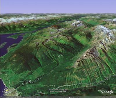 This image was generated using Google's new ©"Google Earth " downloadable program. The accuracy of this image of Chatter Creek's remote cat skiing terrain is quite amazing.
The viewpoint is over Bush Arm, looking WNW, across the Kitchen Range of the Rocky Mountains. The Chatter Creek valley runs NW, from Bush Arm to a point just right of center in the image. Vertebrae Ridge is to the right of the valley and the Kitchen Range is to the left, between the valley and Kinbasket Lake. Below the south end of the East Ridge (the Nose), Chatter Creek veers to the west (left). At this point, East Creek drains into Chatter Creek from the east of East Ridge and Stovepipe Mountain, beyond. Vertebrae Glacier is visible on the east slope of Stovepipe Mountain.
The Chatter Creek cat skiing tenure lies between Vertebrae Ridge, on the east, and Kinbasket Lake, on the west. The tenure extends east of Stovepipe Mountain to include Vertebrae glacier and other regions. The tenure extends from just above Bush arm, in the south, to a point north of Stovepipe Mountain.
Click on the image to enlarge it, to make Lodge Ridge visible, beyond lower East Ridge. Click the browser's "Back" button to return to the Chatter News.
Kinbasket Lake, at the left of the image, lies in the Columbia River trench, about 90 km north of Golden BC. The Chatter Creek cat skiing terrain is on the western flank of the Canadian Rocky Mountains.










<< Home